Advanced Real-time Signal Generation Pro adds support for GPS L1+L5. Select this capability from the Capability parameter under in the GNSS node.
In this topic, GNSSPRO represents the Advanced Real-time Signal Generation Pro capability and GNSS represents Advanced Real-time Signal Generation capability.
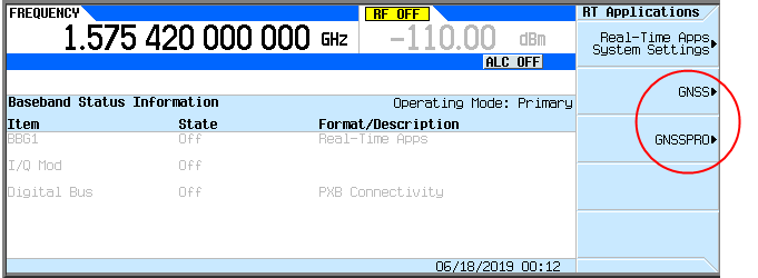
The figure below shows how the N5182B MXG user interface represents these two capabilities with this nomenclature.
GNSSPRO only supports GPS L1+L5, but does not support other constellations like GNSS.
Another difference between GNSS and GNSSPRO is that scenario generation for GNSSPRO occurs inside the DSP, which means that the scenario is generated in real-time and doe not need to be pre-generated to an ‘ags’ file.
In the System Configuration Wizard, you can choose single or dual bands. In order to use GPS L1+L5, however, Dual Bands must be selected and two N5182B/N5172B signal generators are required.

The two N5182B/N5172B signal generators are working under BBG sync mode, so you need to connect the two instruments as shown in the diagram below.

If two instruments are connected, but you have selected one of the Basic Satellite Waveform or Advanced Real-time Signal Generation modes, the two instruments will play the same signal.
Because scenario generation occurs inside the DSP for the GNSSPRO capability, you do not need to create a scenario file before playing. All you need to do is configure the Scenario Settings in the root property grid of the software's GNSS node. These parameters are similar to those under the Scenario Generator node for the GNSS (Advanced Real-time Signal Generation) capability.
|
Parameter Name |
SCPI Example |
Runtime Change |
Comments |
|---|---|---|---|
|
RAD:GNSSPRO:EMANgle <value> |
No |
|
|
|
RAD:GNSSPRO:TROPosphere:MODEl NONE|NATO |
Yes |
|
|
|
RAD:GNSSPRO:IONOsphere:MODEl NONE|KLOBuchar |
Yes |
|
|
|
RAD:GNSSPRO:IONOsphere:ALPHa <index>,<value> RAD:GNSSPRO:IONOsphere:BETA <index>,<value> |
No |
|
|
|
RAD:GNSSPRO:STYPe STATic|DYNamic |
No |
|
|
|
RAD:GNSSPRO:LONgitude <value> |
Yes |
|
|
|
RAD:GNSSPRO:LATitude <value> |
Yes |
|
|
|
RAD:GNSSPRO:ALTitude <value> |
Yes |
|
|
|
RAD:GNSSPRO:NMEA:FILE "string" |
No |
If user set NMEA file from SCPI, user need to copy the file to instrument manually and input a directory of instrument. |
|
|
RAD:GNSSPRO:TRAJectory:MODE REWind|HOLD|ROUNdtrip |
No |
|
|
|
RAD:GNSSPRO:START:GPS:DTIMe "string" RAD:GNSSPRO:START:GPS:WEEK <value> RAD:GNSSPRO:START:GPS:TOW <value> |
No |
User can set start GPS time either by a date-time string like "2019-05-21 00:00:00", or set GPS week and tow individually. |
|
|
RAD:GNSSPRO:POWer:REF <value> |
Yes |
|
|
|
No SCPI |
Yes |
|
|
|
No SCPI |
Yes |
||
|
No SCPI |
Yes |
|
|
|
RAD:GNSSPRO:GPS:ALManac "string" |
No |
If user set almanac file from SCPI, user need to copy the file to instrument manually and input a directory of instrument. |
Note 1: For more information about the parameters, click the Hint checkbox in the GUI. If you are using SCPI commands only, without GUI, send the following SCPI commands to the connected instruments:
RAD:GNSSPRO:GPS:BAND 1 to the instrument that will play L1
RAD:GNSSPRO:GPS:BAND 5 to the instrument that will play L5.
Note 2: If there are two instruments are connected:
|
L1 |
L5 |
Instrument 1 |
Instrument 2 |
Comments |
|---|---|---|---|---|
|
On |
On |
Play L1 |
Play L5 |
|
|
On |
Off |
Play L1 |
Do Nothing |
L5 can’t be turned on after playing |
|
Off |
On |
Play L5 |
Do Nothing |
L1 can’t be turned on after playing |
|
Off |
Off |
Play L1 |
Do Nothing |
A warning pop-up saying it is not valid |
Note 3: If there is only one instrument connected:
|
L1 |
L5 |
Instrument 1 |
Comments |
|---|---|---|---|
|
On |
On |
Play L1 |
A warning pop-up saying L5 can’t be played |
|
On |
Off |
Play L1 |
|
|
Off |
On |
Play L5 |
|
|
Off |
Off |
Play L1 |
A warning pop-up saying it is not valid |
Because the scenario generation occurs inside the DSP, during play, the remote GUI queries the status of the satellites per second, then displays this information on the GUI, i.e. Satellite Settings / Real-time Sky View / Real-time Power View / Real-time Trajectory View nodes.
Above the parameter list, on the left, the Disable Query button can be used to disable (or enable) the query. The button is inactive (grayed out) before playing. If the query is disabled, the GUI will not update the playing status.
Above the parameter list, on the right, the current GPS time that the instrument is playing is displayed.
For GNSS (Advanced Real-time Signal Generation) capability, the Satellite Settings node normally displays the satellite information after playing, and is also used to enable/disable and set the power for each played satellite. For GNSSPRO capability, however, this screen appears empty or will display the previous status of the satellites when State is set Off or the query is disabled.
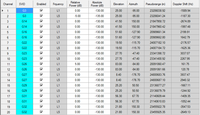
For the same satellite with different frequency, two rows are used to display the information. Three columns can be edited after playing: Enabled, Relative Power, and Absolute Power. Relative Power is relative to the Satellite Power Reference.
For the Relative and Absolute power settings, it is better to set it when the query is disabled.
SCPI Commands: Be aware of the band of each instrument, i.e. sending this SCPI to the instrument playing L1 will only set/get value for the satellite playing L1 frequency.
To Enable/Disable satellite: RAD:GNSSPRO:SATS:ENABle "string",<value>
Example: RAD:GNSSPRO:SATS:ENAB “G3”,0
Example: RAD:GNSSPRO:SATS:ENAB? “G3”
To Set/Get relative power (by dB) of satellite: RAD:GNSSPRO:SATS:ENABle "string",<value>
Example: RAD:GNSSPRO:SATS:RPSCale “G3”,-10
Example: RAD:GNSSPRO:SATS:RPSCale? “G3”
To Set/Get absolute power (by dB) of satellite: RAD:GNSSPRO:SATS:ENABle "string",<value>
Example: RAD:GNSSPRO:SATS:APOWer “G3”,-120
Example: RAD:GNSSPRO:SATS: APOWer? “G3”
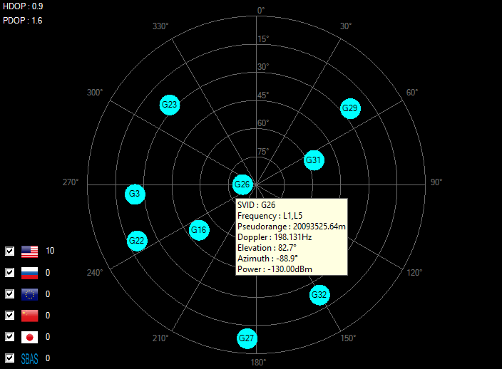
Real-time sky view is used to display the elevation and azimuth of the current satellites. You can move mouse to each satellite to see more information. For L1+L5 satellite, only pseudorange and doppler shift of L1 are displayed on the tooltip. It is similar to the one used in GNSS (Advanced Real-time Signal Generation).
Note that it is empty or display the previous status of satellites when State is Off or the query is disabled.
Real-time Power view is used to display the absolute power of each satellite. It is similar as the one in ‘Advanced Real-time Signal Generation’.
Note that it is empty or display the previous status of satellites when State is Off or the query is disabled.
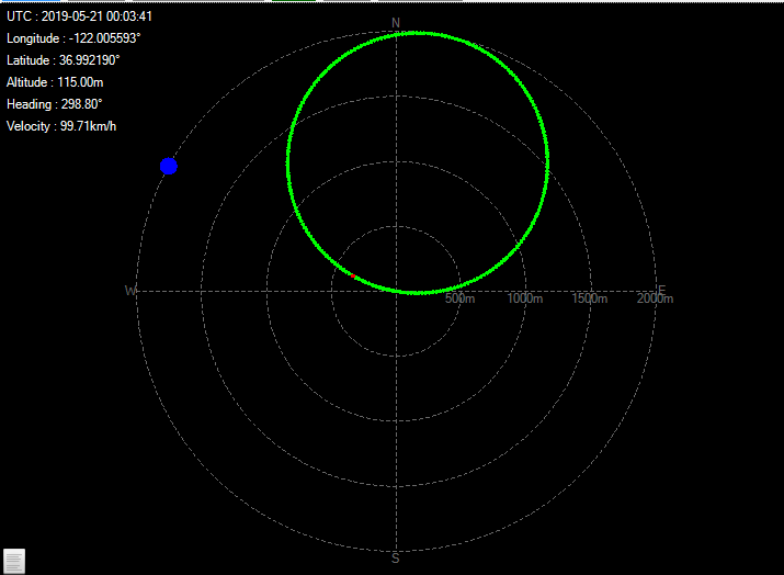
Real-time Trajectory view is used to display the trajectory of receiver, for static scenario type, it will be only one point. It is same as the one in ‘Advanced Real-time Signal Generation’.
Note that it is empty or displays the previous status of satellites when State is Off or the query is disabled.
This node is same as the one used in GNSS (Advanced Real-time Signal Generation).
Marker 1/3/4 selections are same as ones available in GNSS (Advanced Real-time Signal Generation).
SCPI: RAD:GNSSPRO:MKR1 / RAD:GNSSPRO:MKR3 / RAD:GNSSPRO:MKR4
PPS Adjustment is used to adjust the 1 pps marker, resolution is 5 ns.
SCPI: RAD:GNSSPRO:PPS:ADJUst
They all can be runtime changed.
|
Title |
20050122_Atlanta |
|
Constellation |
GPS Only |
|
Latitude |
33.7500052777778 |
|
Longitude |
-84.3833363888889 |
|
Altitude |
300 m |
|
Start Date Time |
2005-01-22 00:08:00 |
|
Duration |
00:30:00 |
|
Type |
Static |
|
Almanac |
20050122.alm |
|
Ephemeris |
20050122_ephemeris.csv |
|
Satellites at the start |
G2,G6,G10,G17,G18,G21,G26,G29,G30 |
|
Notes |
A-GPS scenario #1 defined in 3GPP TS 34.108 v8.9.0 standard. |
|
Title |
20140103_SanFrancisco |
|
Constellation |
GPS + GLONASS + Galileo + Beidou +SBAS |
|
Latitude |
37.775032 |
|
Longitude |
-122.419457 |
|
Altitude |
15 m |
|
Start Date Time |
2014-01-03 20:00:00 |
|
Duration |
02:00:00 |
|
Type |
Static |
|
Almanac |
20140103_GPS.alm 20140103_GLO.agl 20140103_GAL.alm 20140103_BDS.alm SBAS.alm |
|
Satellites at the start |
G3,G6,G14,G15,G18,G19,G21,G22,G24,G27,E3,E4,E5,E6,E10,E11,E12,E13,E19,E20,R2,R3,R4,R8,R17,R18,R19,B12,S133,S135,S138 |
|
Title |
20140103_Circle |
|
Constellation |
GPS + GLONASS + Galileo + SBAS |
|
Latitude |
36.9911233333333 |
|
Longitude |
-122.001838333333 |
|
Altitude |
115 m |
|
Start Date Time |
2014-01-03 17:00:55 |
|
Duration |
00:58:00 |
|
Type |
Dynamic |
|
Almanac |
20140103_GPS.alm 20140103_GLO.agl 20140103_GAL.alm SBAS.alm |
|
NMEA GGA |
Circle.gga |
|
Satellites at the start |
G5,G6,G15,G16,G18,G21,G22,G25,G26,G29,E5,E6,E7,E12,E13,E14,E29,R1,R2,R8,R15,R16,R17,R23,R24,S133,S135,S138 |
|
Title |
20140103_SantaRosa |
|
Constellation |
GPS + GLONASS + Galileo + SBAS |
|
Latitude |
38.481706 |
|
Longitude |
-122.712171 |
|
Altitude |
161 m |
|
Start Date Time |
2014-01-03 10:00:00 |
|
Duration |
01:00:00 |
|
Type |
Static |
|
Almanac |
20140103_GPS.alm 20140103_GLO.agl 20140103_GAL.alm SBAS.alm |
|
Satellites at the start |
G1,G2,G4,G8,G9,G12,G15,G17,G24,G26,G28,E1,E7,E8,E9,E19,E20,E21,E27,R2,R8,R10,R11,R12,R20,R21,R22,S133,S135,S138 |
|
Title |
20140103_Rect |
|
Constellation |
GPS + GLONASS + Galileo + SBAS |
|
Latitude |
38.481706 |
|
Longitude |
-122.712171 |
|
Altitude |
161 m |
|
Start Date Time |
2014-01-03 17:00:30 |
|
Duration |
00:43:29 |
|
Type |
Dynamic |
|
Almanac |
20140103_GPS.alm 20140103_GLO.agl 20140103_GAL.alm SBAS.alm |
|
NMEA GGA |
Rect.gga |
|
Satellites at the start |
G5,G6,G15,G16,G18,G21,G22,G25,G26,G29,E5,E6,E7,E12,E13,E14,E29,R1,R2,R8,R15,R16,R17,R23,R24,S133,S135,S138 |
|
Title |
20140103_Beijing |
|
Constellation |
GPS + GLONASS + Galileo + Beidou + SBAS + QZSS |
|
Latitude |
40.0096856 |
|
Longitude |
116.478479 |
|
Altitude |
100 m |
|
Start Date Time |
2014-01-03 19:56:48 |
|
Duration |
01:00:00 |
|
Type |
Static |
|
Almanac |
20140103_GPS.alm 20140103_GLO.agl 20140103_GAL.alm 20140103_BDS.alm 20140103_QZS.alm SBAS.alm |
|
Satellites at the start |
G1,G3,G7,G8,G9,G11,G17,G19,G26,G27,G28,G32,E1,E2,E3,E4,E10,E11,E21,E22,E23,E24,E28,R9,R10,R11,R16,R19,R20,R21,B1,B2,B3,B4,B5,B6,B7,B8,B10,B11,B12,S127,S128,S129,S131,S137,Q193 |
|
Title |
20140103_Vehicle |
|
Constellation |
GPS + GLONASS + Galileo + Beidou + SBAS + QZSS |
|
Latitude |
40.0096853333333 |
|
Longitude |
116.478479666667 |
|
Altitude |
28.8 m |
|
Start Date Time |
2014-01-03 10:05:57 |
|
Duration |
00:47:54 |
|
Type |
Dynamic |
|
Almanac |
20140103_GPS.alm 20140103_GLO.agl 20140103_GAL.alm 20140103_BDS.alm 20140103_QZS.alm SBAS.alm |
|
NMEA GGA |
Beijing.gga |
|
Satellites at the start |
G12,G14,G15,G18,G22,G24,G25,G31,E10,E11,E12,E18,E19,E25,E26,E27,E30,R1,R2,R3,R4,R8,R12,R13,R14,R19,B1,B2,B3,B4,B5,B6,B7,B9,B10,S127,S128,S129,S131,S137,Q193 |
|
Title |
20180529_GalileoOnly |
|
Constellation |
Galileo Only |
|
Latitude |
38N |
|
Longitude |
0 |
|
Altitude |
100 m |
|
Start Date Time |
2018-05-29 08:20:00 |
|
Duration |
01:00:00 |
|
Type |
Static |
|
Almanac |
20180529_GAL.xml |
|
Ephemeris |
|
|
Satellites at the start |
E2,E3,E7,E8,E11,E30 |
|
Title |
20190611_Beijing |
|
Constellation |
GPS + GLONASS + Galileo + Beidou + SBAS + QZSS |
|
Latitude |
40.0096856 |
|
Longitude |
116.478479 |
|
Altitude |
100 m |
|
Start Date Time |
2019-06-11 00:00:00 |
|
Duration |
01:00:00 |
|
Type |
Static |
|
Almanac |
20190611_GPS.alm 20190611_GLO.agl 20190611_GAL.xml 20190611_BDS.alm 20190611_QZS.alm SBAS.alm |
|
Satellites at the start |
G8,G9,G16,G21,G23,G26,G27,G31,E3,E5,E9,E11,E12,E24,E25,E31,E1,R1,R2,R3,R10,R11,R12,R20,R21,R22,B1,B2,B3,B4,B5,B6,B7,B9,B10,B16,B17,B18,B19,B22,B27,B28,S127,S128,S129,S131,S137,Q194,Q195 |
All the demo scenarios (except 20180529_GalileoOnly) are generated with NATO model for troposphere and Klobuchar model for ionosphere. Ionosphere parameters are as below:
|
Alpha 0 |
4.6566129E-09 |
|
Alpha 1 |
1.4901161E-08 |
|
Alpha 2 |
-5.96046E-08 |
|
Alpha 3 |
-5.96046E-08 |
|
Beta 0 |
79872 |
|
Beta 1 |
65536 |
|
Beta 2 |
-65536 |
|
Beta 3 |
-393216 |